
The little understood implications of Natural England's East Cowes to Wootton coast path running one mile from the coast.
Natural England Proposals Establish Open Public Access Around Osborne Park and Across the Barton Estate.
On the 22nd October Natural England’s public consultation closed on their route for the King Charles Coast Path between East Cowes and Wooton. This proposal runs largely inland and along the busy A3021. DEFRA and Natural England will now be reviewing the hundreds of submissions received from landowners and the general public.
The Marine and Coastal Access Act passed by Parliament in 2009 not only enables a 2,700-mile England Coast Path, but it also provides open public access to areas of countryside and shoreline on the seaward side of the trail.
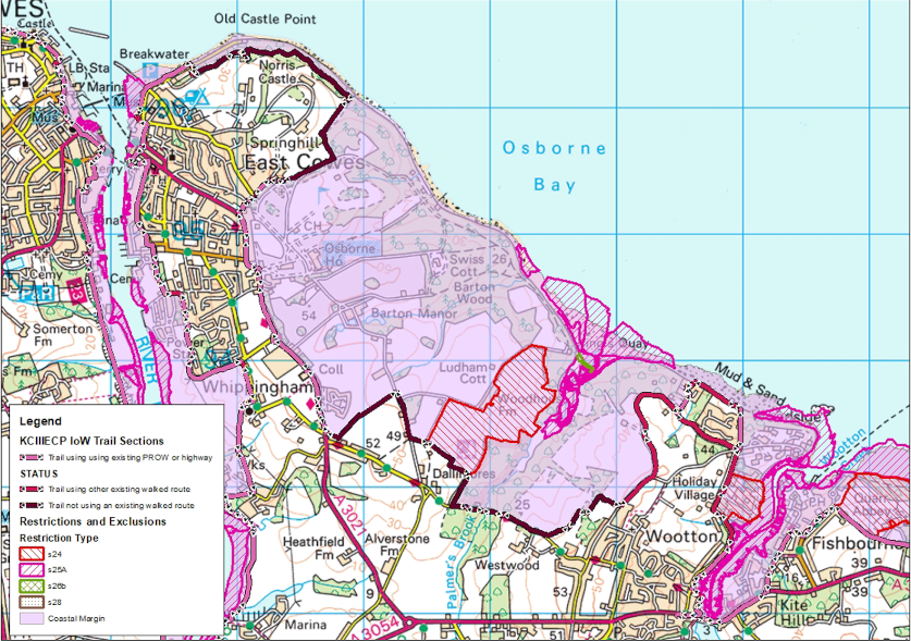
Natural England’s Report for the East Cowes to Wootton includes a map (1) with pink shading that highlights the extensive areas of ‘coastal margin’ as the trail runs up to one mile inland from the sea.
Within this pink coastal margin area categories of land such as buildings with their curtilage, the Osborne Park paid attraction, the golf course, marsh/mudflat conservation sites, and arable fields are ‘excepted’ and not subject to open public access. However, significant areas of woodland, grassland, seashore and access routes between the trail and the sea will be categorised as open access spreading room open for public use.
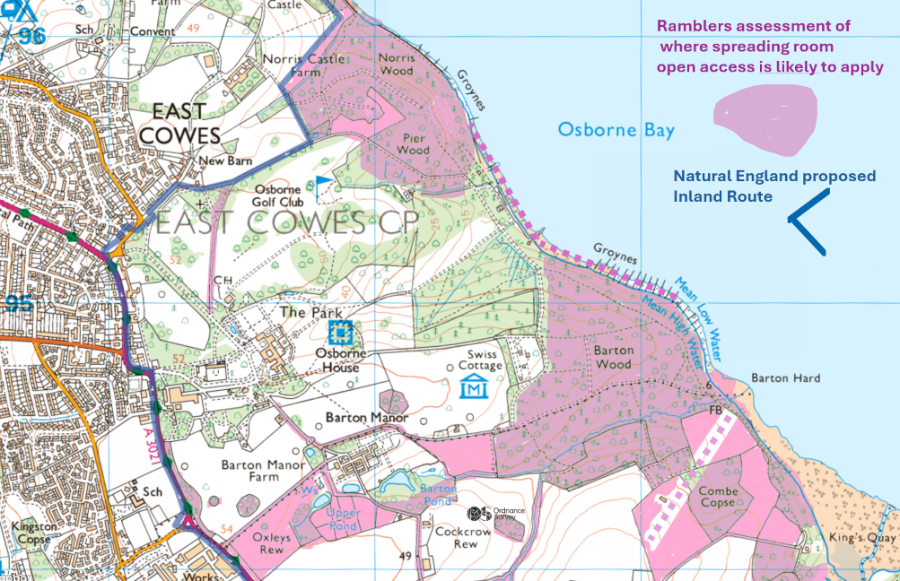
With the benefit of legal advice, the Ramblers have assessed and mapped (2) relevant areas of open access spreading room around the Osborne paid attraction boundary and across the Barton Manor Estate. If the DEFRA Secretary of State approves Natural England’s current proposed inland route. People will be able to enjoy walks along existing tracks through Norris, Pier and Barton woods; explore the foreshore next to Osborne Park and relax on Barton Hard beach.
Hopefully the new English Heritage management team and other landowners are currently having constructive discussions with Natural England about potential truly coastal trail alternatives. Given the level of public concern expressed through the consultation, a Planning Inspector Inquiry will be needed to resolve this complex situation.
This is the last section of the KING Charles III National Trail awaiting resolution. Can we get it sorted out over the next few months, or are we going to see several more years of delay?