
Description:
A walk over the top of the downs between Shanklin and Ventnor, offering fine views and descending into Ventnor and Bonchurch
Distance 6.3 miles
Start:
This walk can be undertaken in either direction but is described as starting in Shanklin and ending in Bonchurch. There is a No 3 bus stop at each end of the trail.
It is possible to return from Bonchurch to Shanklin by foot but the area is prone to landslips and path diversions.
Access information:
There are some steep inclines, steps, and several stiles.
The open downland countryside has splendid views but is prone to misty and breezy conditions.
You may encounter cattle—keep dogs on a short lead.
Refreshments in Ventnor and Shanklin.
Toilets available in Ventnor and Shanklin.
Route:
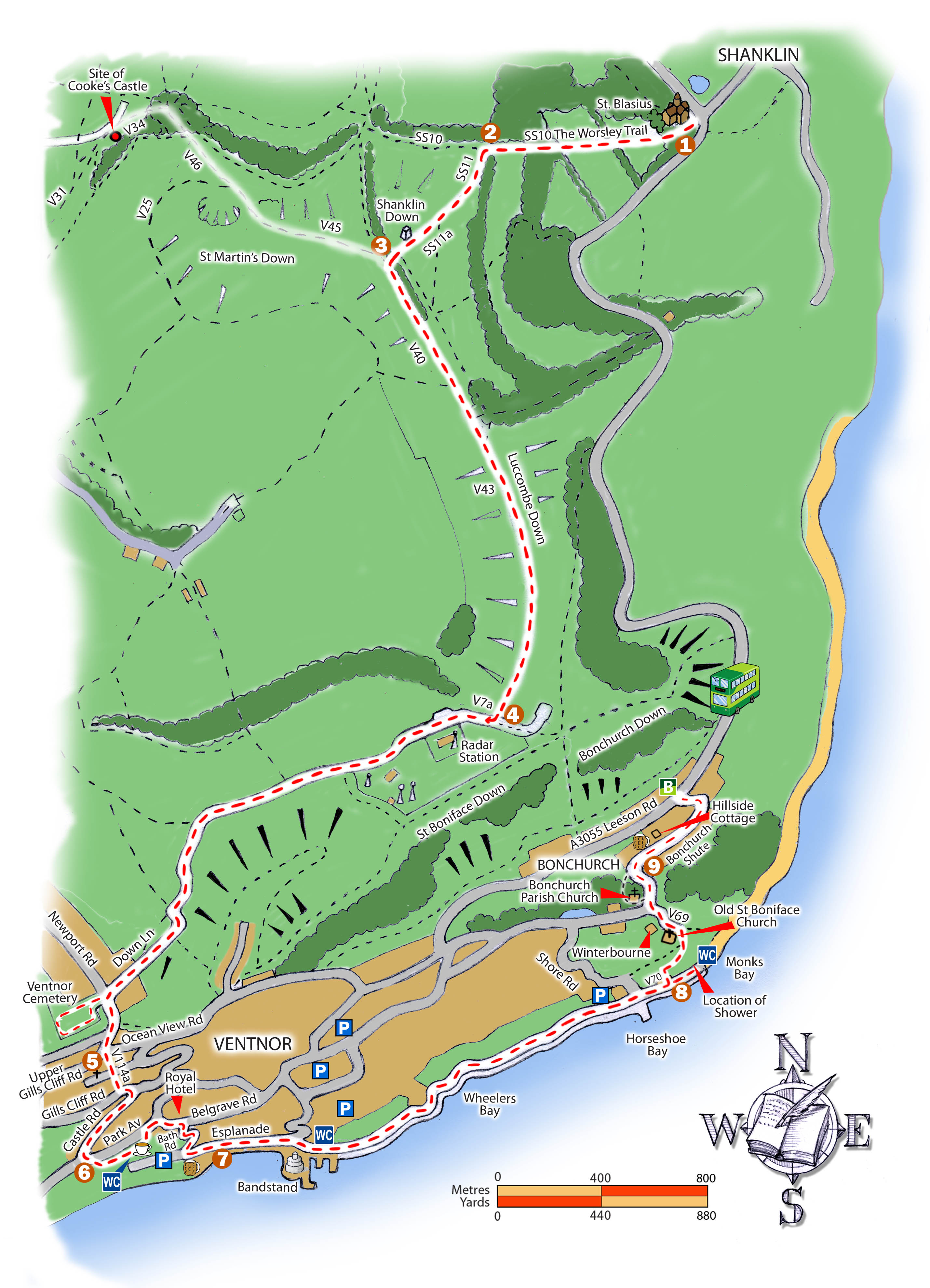
From the Big Mead bus stop, walk uphill on Church Road to St. Blasius Church (1).
Go through the Lych-gate on SS10, The Worsley Trail, to the left of the church,leaving over some stone steps.
Shortly after, there is a Ramblers gate at a field. Go straight ahead to a gate. The path now crosses another field and ends at another gate leading into woodland with
some steps. Go straight ahead past a notice board for Holme Copse on the right. Up more steps and a fairly steep incline with a chicken wire-netting fence on the left.
Continue ahead to a farm gate with a gate next to it. Carry on to another gate (Terry Cheshire) (2)
Make a left turn here onto SS11 (not signposted) and then walk through a gap in a fence with a hedge on the left and a large ash tree on the right. Follow a fairly steep
winding path up the hill to the top. The path ahead now becomes SS11a and leads to a trig point. Here is a fine view of the Island’s central chalk ridge with the white
cliffs of Tennyson Down to the west and Culver Down to the east. Go straight across to a gap in the hedge with a stone bank before a gate and a stile. The stone bank
marks part of the Anglo-Saxon boundary between Newchurch and Brading parishes. It may have prehistoric origins.
A wooden footpath sign SS11a points back to Cliff Copse and Shanklin. (3) Turn left on V40.
Continue south on V40, and before you reach the gate ahead, you will have another fine view of Tennyson Down (west) and Culver Down (east).
Continue through two bridleway gates to Luccombe Down, a National Trust omega sign. You are now in open-access land.
Continue along V43. Just before V43 joins the downs road there are three Bronze Age burial mounds (bowl barrows) to the left of the trail, topped with fern and gorse.
(4) Turn right on a rough road (V7a) with a chain-link fence on the left. Inside that fence is the highest point on the Island, 241 metres (791 ft). When the road
becomes tarmac, you are at the entrance gates of the NATS civil aviation radar station, which was built as RAF Ventnor in 1937 and later used for civil purposes
until the 1960s.
Continue along the tarmac road. To the right, there are several wartime shelters from RAF Ventnor, one with gun portals. On the left, through the fence, are the concrete
bases of wartime radar transmitter masts.
Continue all the way along Downs Lane which emerges at a main road. Ventnor Cemetery is opposite, overlooking the coast and nestling in the downs. Here you
may find the graves of Samuel and Margaret Dick. Return to Newport Road and turn right, descending to the Ocean Fish and Chip shop.
(5) Descend a series of steps on path V114a, St Albans steps, which link Upper Ventnor with the main town. Note St Albans Church was visited by John Betjeman in
1950, who said it was his favourite Island church. Turn left onto Gills Cliff Road by traffic lights. Then, turn right down Castle Road to reach Park Avenue.
(6) Cross the road into Ventnor Park and follow the path left by a stream. Continue along the tree-lined pavement to Belgrave Road and The Royal Hotel, where
Dickens stayed in 1838. Take the road opposite the hotel, Bath Road, which steeply descends to the Spyglass Pub on Ventnor Beach.
(7) Continue on the esplanade, passing the bandstand and follow the coast path all the way to Monks Bay at Bonchurch. The cliffs are important habitats, and you may
see lizards and, in May/June, the rare Glanville Fritillary butterfly.
Dickens built his own wooden shower and used the stream adjacent to The Waterfall cottage for his daily showers.
(8) Return to the Coast Path and ascend path V69 by the 11 th -century Old Church of St Boniface. Then pass Winterbourne House where the Dickens family stayed in
1849. Pass East Dene and continue uphill on Bonchurch Shute to reach St Boniface Parish Church. There are graves of the poet Swinburne, H. De Vere Stacpoole,
author of The Blue Lagoon. The large pyramid-topped tomb belongs to Dr Leeson, who bottled the local water as a remedy. The Rev.James White has a family plot;
White was an author, playwright, and builder of Bonchurch as we see it today and was a friend of Tennyson, Dickens, Thackeray, and Douglas Jerrold. At the right side
of the church, there is a winding “rural path” which emerges back on Bonchurch
Shute near The Pitts.
(9) Continue up Bonchurch Shute, passing the Bonchurch Inn, to Hillside Cottage, the holiday home of John Leech, the illustrator, joining his friends, the Dickens family
in 1849. He drew the cartoon of the shower. Continue to the top of the road to reach A3055 Leeson Road, where you can find bus stops.
Accompanying Audio
Charles Dickens descendants have been involved in the creation of this trail and have recorded the below audio clips to accompany the trail:
Gerald Dickens Location 1
Mark Dickens Location 2
Ian Dickens Location 3
Harry Whinney Location 4
Ollie Dickens Location 5
Marion Dickens Location 6
Lucinda Dickens Hawksley Location 7
Ian Dickens Ramblers AGM Presentation